Your phone is buzzing very loudly. The screen is turning red, signaling Flash Flood Warning; immediate action is required. This is the situation for many people in Washington state in late December 2025. Flooding of historic proportions has resulted from a series of atmospheric rivers that have gone through the region. As a result of these floods, levees have broken, and people have been evacuated across the entire region.
“Flood warning” searches have surged like never before in the whole country as rivers reach their highest levels ever, roads are getting submerged, and towns are battling against water rise. This would have been just another rainy week in the Northwest if it were not for the fact that it is a multi-storm onslaught intensified by climate patterns, and more rain has been forecast. For Americans watching loved ones in the path of a storm or preparing for similar threats, it’s a gripping reminder of nature’s power. Here’s the full breakdown of what’s happening and how to stay safe.
Why Flood Warning Is Trending Across America
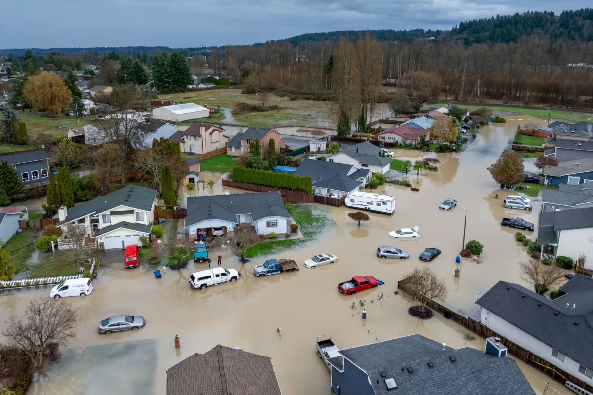
Long, consecutive atmospheric rivers hit the Pacific Northwest hard from the beginning of December, bringing down several feet of rain on the areas that had already been soaked. The bursting of levees on the Green and White Rivers prompted flash-flood warnings, prompting the evacuation of residents in the affected areas.
The National Weather Service issued frequent and intense notifications throughout the state, and the highest-risk localities with over 100,000 people received “Go Now” instructions. The media’s reporting of dramatic rescues and flooding in the neighborhoods prompted search efforts at the highest level.
Requests from Congress to the President for federal emergency assistance demonstrate the enormity of the problem. The next storms are scheduled to hit the area; thus, the warnings will remain active, and people will continue to be attentive.
Main Reasons Searches Are Surging
- Multiple levee failures in King County near Seattle
- Record river crests on the Skagit, Snohomish, and others
- Evacuations affecting thousands in cities like Pacific and Tukwila
- Ongoing atmospheric river parade through late December
Atmospheric Rivers Fuel the Flood Crisis
These “rivers in the sky” pull massive amounts of moisture from the tropics, slamming into the West Coast mountains for epic rainfall. La Niña patterns made this series unusually strong and persistent.
Rainfall totals topped 20 inches in some areas, overwhelming soils and rivers. Warm storm temps melted the lower snowpack, adding runoff volume.
Forecasters rated some as Category 5, rare and hazardous. The parade continues, with systems Tuesday-Wednesday and Thursday.
This setup explains why warnings persist days after initial downpours.
Levee Breaches Trigger Urgent Flash Flood Warnings
The Desimone Levee on the Green River failed on December 15 near Tukwila, flooding areas east of SeaTac Airport. Crews rushed to make temporary repairs as water rose to 60-year highs.
Early December 16, a White River barrier breached in the Pacific, prompting door-to-door evacuations for 7,600 residents. Flash warnings impacted over 45,000 initially.
King County monitored dozens of levees under strain. Saturated ground slowed drainage, prolonging threats.
These incidents turned flood watches into immediate warnings.
Key Breaches and Responses
- Green River (Tukwila): Car-sized hole washed out December 15
- White River (Pacific): Full evacuation early December 16
- Skagit County: Ongoing monitoring, floodplain warnings
- Repairs: National Guard and crews sandbagging round-the-clock
Evacuations and Community Impacts
The places that are at Level 3 “Go Now,” such as Skagit, King, and Pierce Counties, have suffered the most from these orders. The National Guard was helping people by going from one house to another in Burlington.
Some of the rescues had boats that took people off their rooftops; animals were taken to the fairgrounds. Due to roads being closed all over the state, some towns were left without any connection.
Without power and with unusable water, the situation was made even worse. Schools were closed, and businesses were flooded. But the communities have come together to provide places for those without homes and to give donations.
Affected Areas Snapshot
- Pacific: Entire city evacuated overnight
- Tukwila/Kent/Auburn: Neighborhoods inundated post-Green breach
- Snohomish Valley: RV parks and homes submerged
- Skagit floodplain: Tens of thousands under advisory
Preparing for a Flood Warning in Your Area
Flood warnings mean imminent danger; act fast. Know your zone via FEMA maps or local alerts. Evacuate if ordered; don’t wait for visible water. Turn Around, Don’t Drown applies even in shallow flows.
Secure home: elevate valuables, shut utilities if time allows. After the event, avoid floodwater, which is often contaminated. Preparation saves lives in these fast-moving events.
Essential Flood Prep Checklist
- Go-bag: Meds, documents, charger, cash
- Family plan: Rally points, pet provisions
- Insurance review: Standard policies exclude floods
- Alerts signup: Wireless Emergency Alerts on phone
Immediate Actions on Warning
- Move to higher ground instantly.
- Avoid driving through water.
- Monitor NWS or local emergency apps.
- Help vulnerable neighbors if safe.
Climate Ties and Future Risks
Atmospheric rivers that are powered by warmer oceans hold more water, and thus their intensity increases. It is a signal to a larger trend that has been growing gradually; this event repeats itself again and again.
The levees that are part of the infrastructure system are under more pressure than before. There is a loud call for their resilient upgrade and better forecasting.
Conclusion
La Niña usually brings wet winters to the Northwest, so expect more active seasons. Communities are advocating for green solutions, such as wetland restoration. It is now that awareness is preventing a worse tomorrow.
Flood warnings are not merely reminders; they are lifelines during crises such as in Washington. As the recovery begins amid the still-rainy weather, resilience is visible. Be informed and be prepared. What is your local flood risk? Find out today.

 By
By
 By
By
 By
By